Friday 25 November 2011

Thomas Hardy and St Juliot's

In 1870 the twenty-nine year old Thomas Hardy was working as an architect for George Crickmay, based in Weymouth. Hardy had been hoping to become a writer, but had been unable to find a publisher for his first novel, The Poor Man and The Lady. Hardy was working on a second novel, Desperate Remedies, but had not yet found a publisher for that one either and he had reluctantly decided he would have to work full time in the profession for which he had been trained.

Crickmay had been given the commission to restore the parish church at St Juliot in the Valency Valley and he asked Hardy to go and survey the church. When he arrived, the reverend, Rev'd Holder was unwell, and he was greeted by Holder's sister-in-law, Emma Gifford. Four years later, in September 1874 they were married. By now Hardy had published Desperate Remedies, Under the Greenwood Tree, A Pair of Blue Eyes and Far From the Madding Crowd and finally had achieved sufficient success with his novels to allow him to give up architectural work and concentrate on his writing. A Pair of Blue Eyes draws strongly on his experiences whilst in Cornwall and there are many parallels between the heroine Elfride and Emma. Hardy's marriage was not a particularly happy one and after her death he was said to be overcome with remorse which he expressed in his poetry. When in his seventies he returned to St Juliot's and commissioned a memorial tablet for her in the church.

St Juliot's church is only about two miles away from Boscastle so I decided to go and take a look. It's an easy walk along the course of the River Valency. I was retracing the route I had taken on my first day in Boscastle. This time, knowing how muddy it was, and as the walk was short I elected to wear wellies rather than the walking boots, which by now I hated the sight of. They were crippling me and I simply couldn't help thinking it was personal. The wellies were great and a happily sloshed my way along the very muddy track that leads from the carpark in Boscastle up the valley. The wellies also meant I could muck about on the stepping stones I came across and indulge in a bit of light stream bashing.

As the path climbed gradually higher the ground underfoot dried out. I passed the hamlet of New Mills and then after going a bit farther I found myself in a field with no signpost to indicate the direction of the church. There had,  for the last few hundred yards, been a chap walking in front of me. He had now disappeared but as I stood there dithering he emerged from the field up to my left.
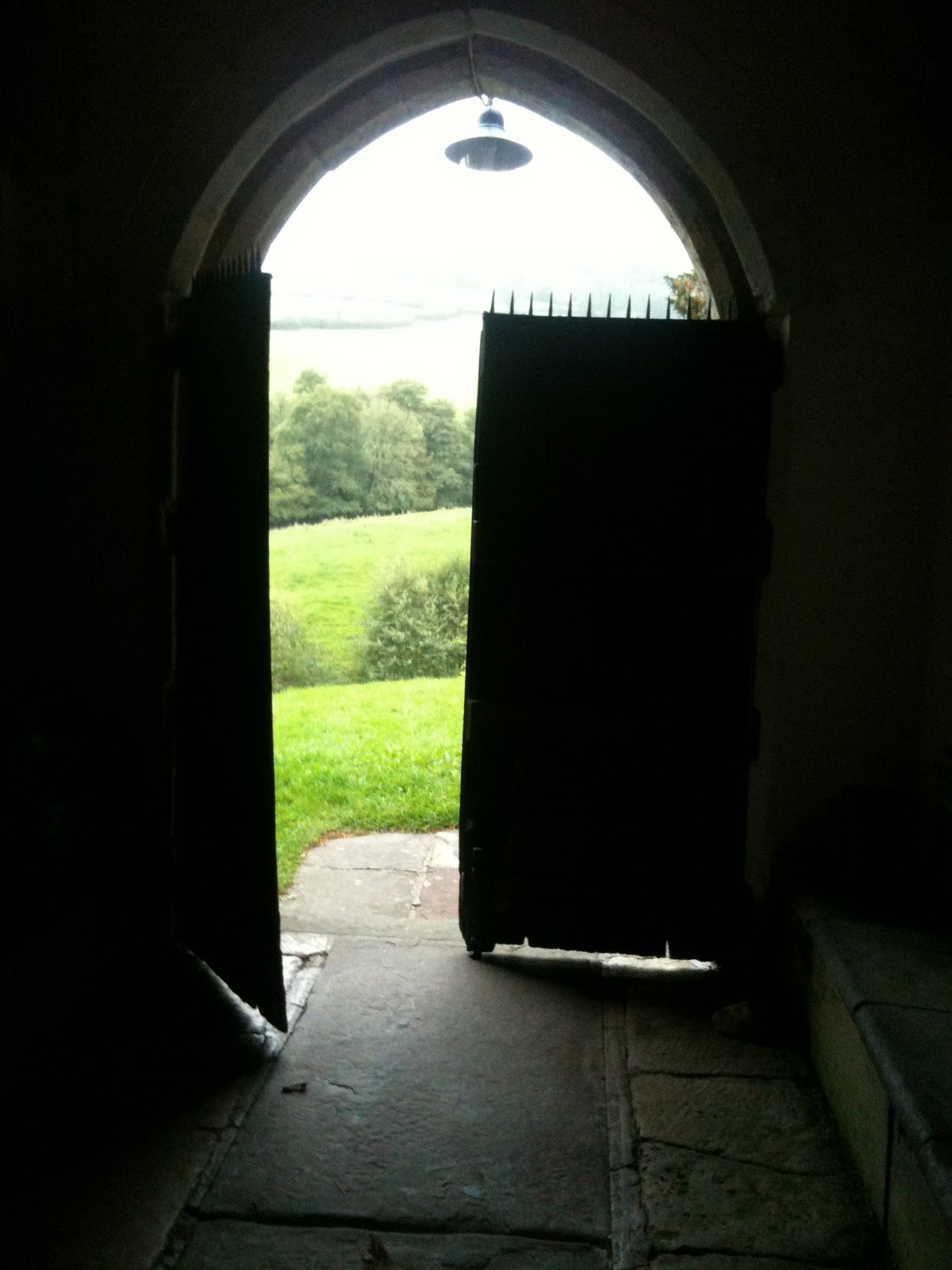
'It's up this way!' he said, and then turned and stode off. I looked after him doubtfully. For one, I was carrying my trusty OS Explorer map which showed the church as being straight on, and secondly, how did he know where I was heading? For all I know he could have meant 'it's this way' to Bude. Or Bideford. I decided to ignore him and carry on across the field straight ahead. Five minutes later the little church of St Juliots came into view.

The church is in a beautiful location and I took five minutes to sit in the churchyard before venturing inside. There was the memorial tablet Hardy had commissioned for Emma and nearby, one for Hardy himself placed there after his death in 1928 'as a record of his assocation with the church & neighbourhood.'

I was very taken with the Hardy memorial window, commissioned by the Thomas Hardy Society to mark the millenium. As I was admiring it, the chap whom I had ignored came into the church. When he saw me he looked a bit abashed.
'Terribly sorry,' he said. 'I told you the wrong way, didn't I?'
'That's ok, I ignored you,' I said. Which didn't sound quite right somehow. 'Erm, that is, I wasn't sure if you knew where I was headed,' I said, backpeddling.
'Yes well, um, I'll leave you in peace, I can always come back tomorrow, I'm only staying in the rectory,' he mumbled. And he was gone.Oh well. Leaving the church I headed back the way I had come to Boscastle.

When I got back to hostel I found that I had company for the first time since I had arrived. A couple in their seventies (people who stay in rural youth hostels are rarely youthful) had turned up for the night. It turned out that Margaret was a keen walker but her husband, Peter, wasn't. However he didn't like her going out walking on her own so insisted on coming with her. But then he wouldn't walk anyway. This made Margaret quite cross and she would complain about him every time he left the room.

As this was my last night I had planned to eat out at one of the pubs. I had been very parsimonious all week and had cooked frugally at the hostel and I had been looking forward to a large plate of whitebait followed by the catch of the day. Peter and Margaret were having none of it. They insisted, absolutely insisted, despite my protestations, that I share their meal. I had no choice but to capitulate, and sat down with them to eat. They were good company though, and it was kind of them to share their steak three ways...

After dinner they said they were turning in for the night. It was only half-past seven and a little early for my bedtime so I decided to try out the other two pubs in the village. The Cobweb Inn was once a warehouse, and was converted to a pub in 1946 although the building itself  dates from the eighteenth century. Inside it was almost deserted which I suppose is not surprising in November. I didn't feel inclined to stay for more than one pint, and wandered over to the Wellington Hotel (The Welly).Of the three pubs in Boscastle, I found The Welly to be the friendliest. The barstaff were friendly and in the comfortable atmosphere it was easy to fall into conversation with other patrons in the bar. I liked it very much. I had a pint of Spriggan (I think it was) from Skinners Brewery.The Wellington, being in the Bridge area of Boscastle at the bottom of the valley and at the confluence of three rivers,Valency, Jordan and Paradise (aren't they lovely names?) suffered badly in the 2004 floods.

'How high did the water come then?' I asked the barmaid, looking around the bar for some kind of marker. She laughed. 'You won't find it here!' she said, 'follow me.' She led me up the stairs to the first floor, where on the wall above the tables was a wooden board stating the flood level in 2004. It turned out the whole of the ground level had been underwater. Not that you would know it now, not here or anywhere in Boscastle, not obviously anyway. Amazingly, the red lamps in the bar of the Welly survived. They were lamps that had orginally been hung in the church of Juliot's by one Thomas Hardy when he undertook its restoration.

Thursday 24 November 2011

Boscastle to Crackington Haven

Last night I had climbed the hill to the Nap for a couple of pints. The pub was quite full with visitors enjoying an evening meal. Suddenly the phone of a woman at the bar beeped with the sound of an incoming text. All us emmets looked up sharply. (An emmet is a pejorative word for tourists but I am reclaiming it.) A text? How? How can you get a text in Boscastle? (You can tell an emmet in Boscastle by the way they keep staring at their phone and then holding it up in the air before stuffing it bad temperedly back in their pocket.) Apparently a certain network named after a citrus fruit is the only one that functions here, and even then it's patchy. (Isn't it interesting how hi-tech products are linked with fruit: Orange, Apple, Blackberry. Nothing branded Melon yet, I wonder why.)

Anyway I was on the wrong network so before I set off on today's walk I indulged in a bit of phone waving standing on top of Queen Victoria's Head (see here and my post dated 22/11/2011.) Don't know why I bothered, no-one had texted me anyway. Sighing, I headed off towards Crackington Haven, today's destination. The first section, as far as Fire Beacon Hill, retraced the route I had taken on Tuesday. once again I got a soaking at Pentargon waterfall before deciding that as I had already climbed Fire Beacon Hill once this week, that I was justified in taking the slightly shorter inland route this time.

Rejoining the main path, the route heads past the spectacular Buckator Cliffs. Since leaving Boscastle I had not seen a soul, and the only sounds were the crashing of the waves below and the screetch of gulls swooping on the crags and cliffs. I noticed that many of the hawthorne trees had a beautiful pale green lichen on them, presumably indicative of the clean, sea air. The path was doing it's usual switchback thing, I soon realised however that the dips and climbs I had experienced so far were simply a warm-up. The coast was gearing up for The Big One - the climb up High Cliff, at 731feet this is the highest cliff in Cornwall. More puffing, grumbling and gasping ensued as I struggled to the top. Once at the top it was magnificent, however. In front of me I could see the empty golden beaches of the Strangles and Little Strand, separated by Samphire Rock. At the top end of Little Strand was Northern Door, an arch formation on the beach. I had intended to climb down to have a look but it was such a long climb down and back that I decided, on this occasion to admire it from afar and come back when I had sorted my footwear out.

It had started raining and in a few minutes I came across the only humans I had seen for hours, a couple headed the other way. We stopped to exchamge pleasantries and they asked me what time I had left Boscastle. 'Half-nine,' I said. Their faces visibly fell. 'What time is it now?' I asked.
'One o'clock,' came the reply.
'Oh but I'm slow, really slow,' I said. 'I'm sure you'll do it much quicker than I did.' I'm not sure if I totally reassured them though.
'It's only an hour to Crackington from here,' said the woman, enviously.

Amazingly, given my pace, it was indeed not much more than an hour before I found myself tottering into the metropolis of Crackington Haven. Considering the time of year and size of the place (tiny) I was rather pleased to have a choice of places to eat. There was the Coombe Barton Inn and the Cabin Cafe. I picked the Cabin for two reasons: it was 200 yards closer and I fancied a cup of tea rather than a pint.


The Cabin turned out to be an excellent cafe. I ordered a tea and got a proper big pot rather than a crappy tea-bag in a cup as you often get, and soup of the day which was celery and cashew-nut and which was superb. They had a lovely comfy sofa and today's papers. Stretched out on the sofa, feeling snug and warm, I felt extremely contented. The buses were not so fortuitious as at Tintagel, a three hour wait, but somehow it didn't seem to matter.
After lunch I had a wander around the beach. Crackington Haven is famous for it's geological formations and folding. The best examples are farther up the coast between here and Bude, as I mention in my post dated 08/11/2011, but all along the coast from Boscastle to Crackington Haven there are plentiful examples of the contrasting grey shales and veins of quartzite sandstone, known as the Crackington Formation. The stones are attractive and there are signs asking people not to take them away, they are an important protection again erosion of the cliffs and bay. See here.


This was washed up on the beach. I don't know what it is - but it immediately made me think of John Donne's poem 'Song'
Go and catch a falling star,
Get with child a mandrake root,
Tell me where all past years are,
Or who cleft the devil's foot
;


The only blot on an otherwise spotless beach was this bag of dog-poo. Why do people do it? I don't understand it. Yes, wrap it up - but the next step is to put it in the bin! These days I notice whenever I go for walks in popular areas, ubiquitous blue or black bags of dog shit - stuffed in hedges, even hanging from trees! Who on earth thinks it's a good idea to put dog shit in a bag and hang it like a sodding christmas decoration? People are odd aren't they?


The bus back to Boscastle took a circuitous route due to various roadworks and dropped me at the top of the hill, so I took the opportunity for a quick pint without having to earn it by climbing the hill before heading down to Boscastle Harbour.

Wednesday 23 November 2011

Boscastle to Tintagel


South West Coast Path signpost


Cornish dry stone wall
Having headed north yesterday, today I thought I would try a section of the coast path south of Boscastle. Leaving the hostel I crossed the new bridge which has been built since the floods. It's much less picturesque than the old one but has a wider span. The old bridge was something of a bottleneck and so as part of the new flood defences it was decided to put a wider bridge across the river. As I climbed out of Boscastle I realised that I should have gone to the loo before setting off. I had drunk several cups of tea at breakfast and I am now of the age when it is definitely one-cup-in-one-wee-out. I looked up and down, there was no one about, so I had a quick pee by the side of the path.
Willapark Coastguard Station

Farther up I soon came to the path which leads to Willapark with it's white coastguard station perched high on the promontory. The door was open so I went to take a look. Three oldish  chaps were in there peering out of the windows.
'I reckon it's that one,' said one of them, looking at a sheet with pictures of various vessels on it.
'That one's white. The one out there is blue,' said one of the others. They turned to me, as I stood in the doorway.

'Come on in!' they said. 'Here, take a look at this, what do you see?'
I peered down the telescope at a tiny spec far out to sea. 'Um, it's a boat, but that's all I can tell you,' I said.
'Never mind,' they said.
I noticed a chart on the wall which said "walkers on coast path". 'Do you track walkers as well then?' I asked. 'If they're on their own, we do, yes. Just in case. You're kitted out fine but you would be amazed what some people wear to walk the path. We try and keep an eye out for them where we can.'
They then told me about an incident a couple of weeks previously when a prison officer had called on them. He had been taking a group of low risk offenders for a walk when one of his party had absconded. Had the coastguards seen him? They confirmed that they could see the offender legging it across a field. Apparently he was finally picked up in a pub in Tintagel. The coastguard told me that they were all volunteers, I was impressed. I waved them goodbye and then as I trudged back down to the main path an awful thought struck me. When I had stopped for a pee it would have been in full view of the coastguard station. I fervently hoped they had been looking the other way.


Ladies Window
The path hugged the coastline and I enjoyed watching the waves pounding the coast. Soon I reached Ladies Window, a natural arch formation in the cliff and I sat for a while on another of those memorial benches. It was about now that I realised that I had a problem with my boots, which were causing me a lot of pain on the front of my feet. They were fairly new and the ground was particularly hard here. Heading on there was a spectacular down and then up at the canyon at the end of Rocky Valley, a beautiful valley where the Trevillett River joins the sea. There is a sign warning you not to go too near the edge, freak waves have been known to sweep people from here into the sea. It looked pretty calm though, so I climbed past the sign and sat on the rocks for a while enjoying the view and resting my sore toes.

The climb up the other side once again reminded me of my lack of fitness as my puffed my way up. In full view now was the controversial hotel known as Camelot Castle. I have never stayed there, and at 200 quid a night I'm not likely to either, but Trip Advisor is worth a read if you are planning a visit. The path rounded another spur known as Barras Nose before dropping down to the (closed) visitor centre and (closed) island on which sits the remains of Tintagel castle. I know it's November but I still couldn't see why English Heritage couldn't open for a few hours. After all, with global warming, winter days can be lovely and warm. There were a few disconsolate souls milling about, obviously disappointed that they couldn't get onto the island. Apparently this is the first year that they haven't opened the castle during the week and unsurprisingly, local businesses say they are suffering.

Superlative North Cornish coast
I plodded up the steps and considered what to do. My feet were killing me now. I decided to head into Tintagel and try and find a pub or cafe open to give them a rest. I wandered up and down the main street; The King Arthur's Arms was open and looked like they had a reasonably priced menu so I stopped there for fish and chips and a fine pint of Cornwall's Pride from Tintagel Brewery and read a few more chapters of Mike Parker's new book, The Wild Rover.

After an hour or so, sated with food and ale I regretfully heaved myself out of my seat and padded in my socks over to the door. I thought about the five miles of switchback coast path I had in front of me to get back to Boscastle. I baulked at the thought of the climb down and up Rocky Valley and decided to take the road for at least the first section. Five minutes along the road I came upon a bus stop. This was rural Cornwall and it was mid-week in November. I fully expected the timetable to say the next bus was due on Saturday afternoon. That's what it would have said in my area of Bath and North East Somerset (BANES!!).  Anyway, I could hardly believe my luck when I read the timetable and a bus was due in three minutes time. Awesome!

So I rode the bus back to Boscastle for two pounds, purchased some provisions in the local store and limped back to the hostel to cook my tea. I was currently the only resident, and with no radio or TV, no phone signal, and no wifi the place was very, um, peaceful. I was getting a lot of reading done.

route here

Tuesday 22 November 2011

Boscastle

I've gone down to Boscastle for a few days. The weather on the way down was foul, driving rain and howling wind, and I was pleased I'd packed quite a few books to read. "I'm not going to get much walking done this week," I thought ruefully. I had arrived at five o'clock last night and had got a soaking trudging up the hill to the pub. But amazingly this morning had dawned bright and clear. Aside from the fleeting visit in April (see post dated 08 April 2011), I had not visited Boscastle before, so decided today to explore the cliffs and the area around the village.

The youth hostel sits right on the harbour, which is why it took such a hammering in the 2004 floods. The building next to it, the Harbour Light, dating from the sixteen century had been completely demolished and the youth hostel itself had been badly damaged. But now it has been completely refurbished, and to a very high standard. Staying there for £10 a night but an absolute bargain. As for the Habour Light next door, that has been completely re-built, resemblingas much as possible the old building that had been destroyed.

The South West Coast path is right behind the hostel so I decided to start my exploration here. The path leads past a small row of cottages known as Penally Terrace. They seem to be mainly holiday cottages now but once housed people working in Boscastle's thriving fishing industry and at the rear were purpose built fish cellars. In the eighteenth and nineteenth centuries Boscastle had a thriving trade exporting pilchards, mainly to Italy. The arrival of the railway at Camelford in 1893 put an end to the seabourne trade however.
The coast path heads of to the right, but I detoured up to Penally Point, the cliff at the end of the harbour, also known as Queen Victoria's Head, due to it's resemblance to her profile. You can sort of see it if you squint and catch it at the right angle...The rock at the top has been worn smooth, no doubt by people like me who discover that the only place in the village that  you can get a phone signal is at the top of the cliff.

The best thing about Penally Point however is the blow-hole, a hole which goes right through the bottom of the cliff. At low tide the sea makes a glorious booming noise as the water rushes through, and when the conditions are right the sea sprays right out across the harbour. It is possible to scuba dive through the blowhole when conditions are calm and there is not too much swell from the sea.
From Penally Point its a down and up to Penally Hill, where a weather vane in the shape of a fish tells sailors the wind direction, as it's not possible to judge this from the calm of Bostcastle Harbour. Considering it was November and yesterday had been awful, I was pleased that the sun was attempting to shine as I made my way along the path to Pentargon waterfall. At times the path ran un-nervingly close to the edge of the cliff and notices warned the unwary. It was not so much the 'steep' as the 'crumbling' bit that un-nerved me, especially after the downpours of the day before.

It was soon after Pentargan waterfall that I began to realise how hopelessly unfit I was. The path climbs steeply up and around the cliff and I was wheezing and gasping for breath. I dragged myself up the path, ever thankful for the nice, thoughtful people who had put benches along the way to remember loved ones. 'How much nicer than a vase or a big headstone in a forgotten cemetary,' I thought, as I slumped gratefully onto the seat. By the time I had struggled up Fire Beacon Point I had had enough of the climbs. My fitness definitely needed working on. I headed on a path inland and picked up a lane near Manor Farm. A swift change of route was required when I was chased by a farm dog - this seemed to be a feature of man of my walks in Cornwall, but eventually I crossed the B3263 and made may way down the steep lane to New Mills in the Valency Valley. New Mills is a cluster of cottages and the path went along the front of one of them before turning into a very pleasant, if somewhat muddy, path alongside the River Valency. As it meandered and tinkled along, it was hard to believe that this river had been the cause of so much destruction a few years previously. I appreciated the lack of gradient very much and fair skipped my way into the carpark at Boscastle where the path comes to an end.

I decided that I had earned a pint. I knew that there were three pubs in the village, two I had spotted though not yet tried, so where was the third? I asked directions in one of the shops and he pointed me up the hill. I then realised that Boscastle is in fact two villages - the one on the harbour and the one on the hill. They have gradually been merging as new places are built, but are still distinct. The harbour area had built around the sea trade, whilst the upper partof Boscastle had grown up around the Norman castle built by Bottreaux, and from whom Boscastle derives its name. Nothing remains of the castle now, which is simply a picnic area with nice views, easily accessible from the road up the hill.

And what a hill! The Old Road climbs steeply up, and then flattens out as it bends to the left. This is cruel as a right hand bend reveals this plateau to be merely a resting point before the hill climbs up even more steeply. There are, however, some wonderful old cottages flanking the road, with fantastic names: Tinkers, Sharrocks, Smugglers, Kiddlywink. (Kiddlywink, by the way, is an old Cornish name for a beershop.)

Finally the pub sign for the Napoleon Inn came into view and I staggered gratefully across the threshold and towards the bar. The "Nap" is a lovely sixteenth century building, with huge walls and flagstone floors. They also sell beer straight from the barrel which, of course, I wholeheartedly approved of. The pub is owned by St Austell Brewery and I had a pint of Trelawney and a pint of Tribute, both of which were excellent. Going down the hill was much easier than climbing up it, especially after a couple of pints. As I headed back to the hostel I considered that all-in-all it had been quite a successful day.

My route is here.

Friday 4 November 2011

Dyrham Park Disaster


Yvonne, fit and strong from walking the Camino de Santiago de Compstela, suggested we go for a 'long walk.'
'Ok,' I said, 'how long? Ten miles?'
Yvonne looked at me in disgust. 'Ten miles? she said incredulously. 'No, let's do twenty.'
I shook my head. 'No, I can't manage twenty,' I protest feebly. 'Ten. Fifteen at the most.'
'Leave it to me,' said Yvonne. She texted me the departure point, at the back of Dyrham Park and I duly arrived in my car at the appointed time of half-past nine. Dyrham Park supplied most of the exterior shots for the film The Remains of the Day, although the interiors were mostly filmed at nearby Badminton House. Dyrham is also on the route of the Cotswold Way and it was a section of this route that Yvonne proposed that we walk for the day. This sounded good to me, and we strode through the village and then turned right on a footpath in the direction of Bath.


The day started well, albeit a little drizzly. The route was varied and pleasant, alongside fields and small ponds and passing through Dyrham Wood. In the wood a little box on a post had some usefuls in it, left by other walkers, including a couple of biscuits, a card with the number of a local B&B and a notebook for leaving messages, presumably for lost companions. 'Dear xxx, we're heading for the pub at Tormarton. Hurry up, it's your round.' That type of thing. We debated whether to eat the biscuits. Alfie (Yvonne's Westie) was in favour, but I was not so sure. There would no doubt be people passing this way whose need was greater than ours, after all we had only been walking for twenty minutes. We put them regretfully back in the tin and strode purposefully on.

We had speculated whether we would be able to get a coffee at the White Hart in Cold Ashton but when we got there the pub had closed. Permanently closed. There was, however a sign for a cafe along the road so we decided a small detour was in order. The cafe was a little gem, a small building on a walking farm. The play area outside was now being used to house a group of pigs, who seemed to like it, although I was disappointed to note that none of them seemed keen on using the slide or the little climbing frame.

(If one wanted to give an example of the versatility of the English language one need look no further than the pig. Pigs have been around for a very long time, domesticated from the wild boar, and English words for pigs are plentiful. The animal itself could be a pig, a swine, a hog, a sow, a grunter, a squealer, a shoat or a piglet. A group of pigs, depending on the type, the age and whether or not they are on the move could be called swine, a drift, a drove, a herd, a sounder, a farrow, a flock or a doylt. )

The proprietor of the cafe was lovely, and she had no problem with us bringing either our muddy boots or Alfie into the warm room. I was unable to resist a huge piece of carrot cake and Yvonne, who was suffering from a pre-existing blister, managed to scrounge a couple of plasters. After our refreshments we pressed on through the village of Cold Ashton itself and then along a long, long lane before once again crossing fields.

The route started to climb up to Lansdown and we arrived at the site of the Battle of Lansdown Hill in July 1643. (That's the date of the battle, not when we got there.) The field in front of us was apparently the site of a significant skirmish between the Royalists and the Parliamentarians in the English Civil War or if you're a fan of Christopher Hill, the English Revolution. (Personally I think Professor Hill was rather pissed off that the French and the Americans, let alone the Russians, had all had their revolutions, and so determined to make this one our very own 'English Revolution', so claiming that we were the first.)

As we followed the course of the path around the hill, it was not so much the English Civil War that struck me, it was much older history. We passed the site of a Roman Villa,although nothing remains of it now, and an Iron Age fort and although I am not prone to superstition I caught something in the atmosphere which was hard to define, the ephemera of long dead people who had walked this route over the centuries.

More prosiacally, the path also marches through Lansdown Golf Club, 'a traditional private members club', and we sternly informed Alfie that this was not the place to stop for a pooh. 'As if I would,' he muttered.

Finally we reached Prospect Stile which gives, as Jane Austen would say, A Fine Aspect over all of Bath and the surrounding countryside. We sat on the bench and ate our lunch. I was by now getting a little concerned as it was gone three o'clock and at this time of year the nights were drawing in. It was time to turn around and head back. In view of the time we decided to head back straight across the race course and the golf course. I was starting to worry about the dwindling light and suggested an alternative route back. This proved to be a mistake.

It looked straightforward enough on the map, a shortcut down to Langridge and then through a few fields to rejoin the Cotswold Way. We stopped for a quick look at St Mary Magdelene Church, Langbridge, a beautiful little twelfth century building with a magnificent norman arch before heading up a steep lane. Three or four fields on we would rejoin the proper path and then head back.

What the trusty OS Map didn't show, however, were the horses and cows. Yvonne was worried about taking the dog through fields of cows and horses. And, if I'm honest I wasn't too keen either. But we made a run for it though a field full of young horses, during the course of which Alfie slipped his lead. Ahead of us was a field of full cows and another one of horses. We dithered for a while  and eventually we decided to backtrack up a lane.

By the time we reached the proper route again it was dark. I dug out my headlamp and we peered at the map. Suddenly mooing up in front brought my companions to a halt. Yvonne suggested we traverse the field next door and try and pick up the route at the other end. This was not as straightforward as we hoped, we were reduced to crawling through brambles, under barbed wire and stepping in unseen cowpats in the dark. I don't think it's pushing it to say we were all getting a little bit pissed off. Eventually, god save us, we reached a lane and stayed on it until we reached the A46. We traipsed down here for a while but I knew a decision awaited us. Go through Dyrham Woods in the pitch dark or make a massive detour along a busy road, in the dark, with no footpath.

'It'll have to be the wood,' I said, wearily. We had no choice. Why are woods so creepy at night? I blame The Blair Witch Project. We managed to get through it though and trudged disconsolately on. When we were almost at the end of the path at Dyrham I slipped and fell down hard on my right buttock. 'Damn, fuck and bollocks!!' I said. Which I think under the circumstances was quite restrained.

By the time we finally reached our cars, eleven hours after our jaunty departure, we were tired, dishevelled, and stinking of cow shit. Only Alfie who had earlier been complaining he was tired seemed undaunted, jumping for joy as the car came into view.

'Errm, that was lovely, Yvonne, we must do it again sometime,' I said, unenthusiastically.
'Uh, yes, we must,' she responded, with even less enthusiasm.

I'm sure we will go for another walk. Sometime. Maybe.

Our route